
Open User Map
Open User Map is a WordPress plugin that lets visitors add and edit locations on an interactive map with approval workflows and no coding required.
Visit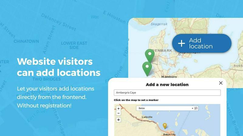
About Open User Map
Open User Map is a powerful, interactive mapping plugin for WordPress that transforms how you and your website visitors engage with location-based content. At its core, this tool lets you create a dynamic map that your visitors can actively contribute to, with features like frontend submissions, approval workflows, and extensive customization options. What sets Open User Map apart is its remarkable simplicity: there is no coding required, no need for a Google Maps API key, and no complex setup process. You can have a fully functional, community-driven map running on your site in minutes.
The product is designed for website owners, community managers, local business directories, tourism boards, event organizers, and anyone who wants to crowdsource location data from their audience. Whether you need a map for neighborhood recommendations, event grounds, campus guides, or service area highlights, Open User Map provides the infrastructure without the technical overhead. It is the number two map plugin on WordPress.org with over 15,000 active installs and a perfect 100% five-star rating, a testament to its reliability and user satisfaction. The plugin offers both a free version on WordPress.org and a premium PRO version with advanced features like custom image maps, advanced filters, upvotes, star ratings, and opening hours. The main value proposition is clear: you get a professional-grade, interactive map that your community can help build and maintain, all without touching a single line of code or paying for third-party API services.
Features of Open User Map
Frontend Location Submissions and Editing
Enable your website visitors to add and edit locations directly on your map with a simple, intuitive interface. Clicking the Add location button allows users to place a marker and submit details, which then await your approval before going live. The editing capability empowers users to update their existing locations, ensuring the map always reflects the most current information without requiring manual intervention from you. This feature turns your map into a living, breathing resource that grows and improves with community input.
Lines and Areas
Go beyond simple location markers by adding routes, paths, zones, and regions directly to your map. This feature lets you highlight trails, service areas, event grounds, neighborhoods, construction zones, or any custom shape that helps visitors understand your map at a glance. Distances and area sizes are calculated automatically, so routes and polygons can include helpful measurements right out of the box. This is ideal for maps that need to communicate spatial relationships beyond just points on a grid.
Custom Image as Map
Upload any image and transform it into a fully interactive map, whether it is an overlay, floor plan, event layout, game map, product diagram, campus guide, or seating chart. Users can place markers directly on top of the image with the same powerful functionality as a traditional map. You can add locations, display custom fields, enable filtering, and create an engaging, clickable experience tailored exactly to your use case. This feature breaks the mold of traditional cartography and opens up endless creative possibilities.
Advanced Filter Interface
Create a filter sidebar that appears next to your map, allowing visitors to filter locations by any custom field you have configured. You can also add custom HTML content sections to display additional information or branding, giving users a clearer, more intuitive way to explore your mapped data. This feature transforms a simple map into a sophisticated data exploration tool, making it easy for users to find exactly what they are looking for without scrolling through hundreds of markers.
Use Cases of Open User Map
Community-Driven Local Business Directory
Create a map where residents and visitors can add and review local businesses, restaurants, shops, and services. With the star rating and upvote features, the best places naturally rise to the top. The opening hours custom field with a live Open Now indicator makes the map incredibly useful for people looking for places that are currently open. Approval workflows ensure that only verified, high-quality listings appear on your map, maintaining trust and accuracy.
Event and Festival Grounds Mapping
Use the Lines and Areas feature to map out event grounds, camping zones, parking areas, and stages for festivals, conferences, or sporting events. The Custom Image as Map feature lets you overlay a map onto a site plan or aerial photograph. Visitors can add their own markers for points of interest like food trucks, first aid stations, or meeting points, creating a collaborative guide that enhances the attendee experience.
Tourism and Travel Guide
Build an interactive travel guide that locals and tourists can contribute to by adding hidden gems, scenic viewpoints, hiking trails, and recommended restaurants. Regions can be used to define neighborhoods or districts, making it easy for visitors to explore specific areas. The advanced filter interface allows users to filter by activity type, price range, or user rating, turning your map into a comprehensive travel resource that grows richer with every contribution.
Campus and Facility Navigation
Create an interactive map for a university campus, corporate headquarters, or large facility. Use the Custom Image as Map feature to upload a floor plan or campus aerial view. Visitors can add markers for departments, offices, restrooms, parking, and study spaces. The upvote feature helps highlight the most popular or important locations, while the approval workflow ensures that only accurate and appropriate information is displayed.
Frequently Asked Questions
Do I need a Google Maps API key to use Open User Map?
No, you do not need a Google Maps API key. Open User Map is designed to work without any third-party API keys or complex setup. This saves you time, money, and the hassle of managing API usage limits and billing. The plugin works out of the box with its own mapping infrastructure.
Can I moderate submissions before they appear on the map?
Yes, Open User Map includes a built-in approval workflow. When a visitor submits a new location or edits an existing one, it goes into a pending state that awaits your review. You can approve, reject, or edit submissions from your WordPress dashboard, ensuring that only accurate and appropriate content goes live on your map.
Is there a free version of Open User Map available?
Yes, there is a fully functional free version available on WordPress.org. The free version includes core features like frontend submissions, approval workflows, marker categories, and basic customization. The PRO version unlocks advanced features such as Custom Image as Map, Advanced Filter Interface, Upvotes, Star Ratings, Opening Hours, and Regions.
What kind of custom fields can I add to locations?
Open User Map supports a wide range of custom field types including text boxes, links, checkboxes, dropdowns, and opening hours. This flexibility allows you to gather exactly the information you need from map interactions, whether it is a business website, phone number, operating hours, or any other data point relevant to your specific use case.
Pricing of Open User Map
Open User Map offers a free version available on WordPress.org and a PRO version with advanced features. The PRO version is available through a one-time purchase or annual subscription on the Open User Map website. A 7-day free trial of the PRO version is available with no credit card required and no automatic conversion to a paid subscription after the trial ends. Specific pricing tiers and costs are available on the official Open User Map pricing page.
Similar to Open User Map

Built2WinWeb AI SEO
Custom PHP websites, AI Indexing Pack ($599 one‑time), and WebAgentScan SaaS ($9/mo). MCP, A2A, llms.txt, full ownership.
Unifyca
Unifyca turns scattered client website information into one organized platform for documentation, maintenance, and backups.

PageLens AI
PageLens AI audits AI-built websites, revealing launch risks and providing actionable fixes to ensure a safe and successful launch.

Shadcn Examples
A curated collection of premium Shadcn UI components and examples for building polished React and Tailwind web apps.

Webleadr
Webleadr helps you effortlessly find and contact web design leads and businesses without websites in just a few clicks from anywhere.

Idearium
Idearium crafts memorable websites that drive growth for your business.

FilexHost
FilexHost instantly creates a shareable link for any file you drag and drop.

Crawlkit
CrawlKit is an API that simplifies web scraping, enabling easy data extraction from any site or platform with a single.